
Location-based search ranks or filters results by their proximity to a point on a map, usually a user's current position or a typed address. Three parameters drive it every time: a center point (latitude and longitude), a search area (a radius, box, or polygon), and a ranking preference (sort by distance, popularity, or some blend of both). Building it comes down to three steps:
- Geocode the input address or device coordinates into lat/lng.
- Index your records with a geo-aware field type.
- Query and rank using a spatial filter, then order results by distance or relevance.
Key Takeaways
Location-based search works when a center point, a spatial filter, and a distance-aware ranking rule are combined and backed by clean, regularly refreshed geocoded data.
| Point | Details |
|---|---|
| Three core parameters | Every implementation needs a center point, a search area (radius, box, or polygon), and a ranking preference. |
| Filter first, rank second | Apply the spatial filter to narrow candidates before computing distance and sorting, never the reverse. |
| Match the query shape to the use case | Use radius for "near me," boxes for map viewports, and polygons for irregular service areas. |
| Freshness beats raw precision | A stale geocode causes more user frustration than a slightly imprecise but current one. |
| Guard against spoofed coordinates | Cross-check device GPS against IP location and flag abrupt or repeated location changes. |
Table of Contents
- What Are the Core Components of Location-Based Search?
- Radius, Box, or Polygon: Which Spatial Query Fits?
- How Should You Handle Geocoding and Data Quality?
- Which APIs and Databases Handle Geo-Search Best?
- How Do You Balance Distance and Popularity in Ranking?
- What UX Patterns Cut Failed Location Searches?
- How Do You Optimize Performance for Geo Queries?
- What Privacy Controls Does Location Search Need?
- How Do You Ship a Location Search Feature Step by Step?
- How Does MarketplaceAnywhere Apply Location Search?
- What Happens When Location Data Is Wrong or Imprecise?
- Why Does Location Data Freshness Matter for Search Results?
- How Do You Scale Location Search Across Large Datasets?
- How Should Language and Culture Shape Location Search?
- How Do You Handle Borders, Time Zones, and Edge-Case Locations?
- How Do You Prevent Location Spoofing and Abuse?
- An Editorial Take on Building Location Search Right
- Sources
What Are the Core Components of Location-Based Search?
Every location search starts with getting a center point. That center comes from three sources: a typed address run through a geocoder, a device's GPS coordinates, or a saved location like "Home" or "Work." Geocoding is where things usually break first. Free-text addresses with typos, missing unit numbers, or ambiguous city names ("Springfield" exists in more than 30 U.S. states) fail silently or return the wrong point entirely.
Once you have a center, your database needs geo-indexed records to search against. Most modern engines support dedicated geo field types. Elasticsearch uses geo_point for single coordinates and geo_shape for polygons and areas, and Elasticsearch's geo_distance query treats those fields differently from a plain text or numeric field. Skipping the geo index and calculating distance manually against raw lat/lng columns works at small scale, then collapses once you cross tens of thousands of records.
The actual query lifecycle runs in a fixed order:
- Apply the spatial filter (radius, box, or polygon) to shrink the candidate set.
- Compute distance for each surviving record.
- Order results by your ranking rule, distance, popularity, or a weighted mix.
- Return a capped result set to the client.
Pro Tip: Never calculate distance before filtering. Filter first to cut your working set, then compute distance only on the records that already passed the spatial test. Reversing the order burns CPU cycles on points you're about to throw away.
Radius, Box, or Polygon: Which Spatial Query Fits?
The shape of your search area changes both the user experience and the query cost. Picking the wrong one is a common early mistake.
- Radius searches draw a circle around the center point and are the default for "near me" queries. Typical presets map to real behavior such as walking distance, a short drive, city-wide scale, and regional scale for search radii. Meilisearch's geo radius filter works exactly this way, returning documents inside a defined circle.
- Bounding boxes are rectangles, cheaper to compute than a true circle because the math is simple min/max comparisons rather than trigonometry. Use one when rough accuracy is fine, like a map viewport query that only needs "what's currently on screen."
- Polygons handle irregular shapes: delivery zones, school districts, service areas that follow rivers or highways instead of a clean circle. They cost more to index and query but are the only option when a circle or box would misrepresent the actual coverage area.
Filtering and ranking are separate jobs. A radius query narrows the candidate pool; sorting by distance afterward decides the order those candidates appear in.
How Should You Handle Geocoding and Data Quality?
Bad input data is the single biggest cause of failed location searches, and most of it is preventable at the point of entry. Address autocomplete cuts this off early: when a user picks from a suggested list instead of typing freehand, the string that reaches your geocoder is already validated, which Gravity Geolocation's proximity documentation points to as one of the more reliable ways to reduce failed geocodes.
On the storage side, a few habits pay off repeatedly:
- Store canonical lat/lng as numeric fields, never as concatenated strings.
- Use your engine's native geo type (
geo_point, GeoJSONPoint) instead of two separate float columns where the platform supports it. - Support multiple locations per record when a business has more than one relevant point, a storefront address and a separate fulfillment warehouse, for instance.
- Treat computed distance fields as display or ranking values only. Meilisearch documents
_geoDistanceas generated at query time, not a stored, filterable attribute.
Pro Tip: If a record's location changes often (a food truck, a mobile service provider), re-geocode on every update rather than caching an old point. A stale coordinate is worse than no coordinate, because it looks authoritative while being wrong.
Which APIs and Databases Handle Geo-Search Best?
The right tool depends on whether you need a places database, a search engine, or a general-purpose store with geo support bolted on.
- Google Places Nearby Search takes a center and radius and supports a
rankPreferenceof eitherDISTANCEorPOPULARITY. The Nearby Search API caps the radius at 50,000 meters, so anything beyond a 50 km circle needs a different approach, like paginating across multiple centers. - Elasticsearch offers
geo_distanceandgeo_shapequeries, and lets you choose between arc and plane distance computation, a real trade-off between accuracy and speed covered in the geo_distance query docs. - Algolia stores coordinates in a
_geolocattribute and applies geographical ranking automatically once that attribute is set, detailed in its geolocation guide. Default precision and result caps shape how tightly proximity sorting behaves in dense areas. - Meilisearch computes
_geoDistanceat query time for sorting, alongside its radius filter capability. - MongoDB uses the
$nearSphereoperator against a2dsphereindex to sort by distance, and MongoDB's own reference documents optional$minDistanceand$maxDistanceparameters for bounding results without a separate filter step.
The 50,000 meter radius ceiling on Google's Nearby Search is worth flagging on its own: it's a hard platform limit, not a configurable setting, and teams building regional or nationwide search on top of Places often discover it only after launch.
How Do You Balance Distance and Popularity in Ranking?
Filtering and ranking solve different problems. Filtering decides who's in the room; ranking decides who gets called on first. A radius filter might leave you with 400 candidates, but the order those 400 appear in is a separate decision, and it's the one that actually shapes user behavior.
Weighting distance against popularity is where most of the tuning work happens. A pure distance sort surfaces the closest result even if it has zero reviews; a pure popularity sort might rank a great shop 40 km away above a decent one three blocks over. Most production systems blend the two, often with distance mattering more inside a tight radius and popularity taking over as the radius widens.
- Watch for default result caps. Many engines stop returning matches after a fixed ceiling (commonly cited around 1,000 hits) even when more technically match, which matters in dense urban datasets.
- Precision settings matter too. Some engines round coordinates into buckets (roughly 10 meter increments in certain configurations) that are fine for a city search but too coarse for something like adjacent parking spots.
Pro Tip: Test ranking weights against both a dense city dataset and a sparse rural one. A blend tuned only on New York data will feel broken in Wyoming.
What UX Patterns Cut Failed Location Searches?
The interface choices around location search matter as much as the backend query logic, because most failed searches trace back to bad or missing input rather than a broken algorithm.
- Address autocomplete on every location input field, cutting typos and ambiguous entries before they ever reach the geocoder.
- A locator button that requests device location directly, with a clear fallback (a manual address field) when the user declines the permission prompt.
- Radius presets instead of a raw slider: label them in plain terms, "1 km, walking distance" or "5 km, short drive," so users understand what they're choosing rather than guessing at an abstract number.
- Empty state handling that suggests a concrete next step, expand the radius, or browse a related category, instead of a blank screen with no path forward.
Local marketplaces lean on these local retail digital experiences constantly. A platform built for local selling succeeds or fails on whether the first search a new user tries actually returns something nearby.
How Do You Optimize Performance for Geo Queries?
Two engineering decisions drive most of the performance difference between a location search that feels instant and one that lags: how you compute distance, and how much of that computation happens on an index versus on the fly.
- Arc versus plane calculation is the first fork. Arc computation accounts for the Earth's curvature and stays accurate over long distances or near the poles; plane computation is faster and perfectly fine for local, short-range queries where the curvature error is negligible.
- Indexed geo points beat runtime math every time. A query against a
2dsphereorgeo_pointindex resolves in milliseconds; calculating distance against unindexed raw coordinates for every row does not scale past a few thousand records. - Adapt the radius to density. A fixed 5 km radius returns hundreds of matches in Manhattan and zero in rural Montana; adjusting the radius (or using a
minimumAroundRadius-style override) based on local hit density keeps results useful in both. - Cap and paginate server-side. Wide-area queries without a result cap can return tens of thousands of rows, most of which the user will never scroll to. Page the results and let the client request more.
Pro Tip: Log your empty-search rate by region. A spike in empty results from one geography almost always means your default radius is too tight for how sparse that market actually is.
What Privacy Controls Does Location Search Need?
Every location-search feature needs an easy way to turn results off or override them manually, not just request permission once at launch. Ask for approximate location when that's enough (a city-level radius search rarely needs GPS-level precision) and explain in plain language why you're asking for anything more precise.
- Build a graceful fallback: manual address entry with autocomplete when a user denies location permission.
- Never assume one country's privacy framework applies globally. Rules on location data vary widely, and it's worth checking your platform's own compliance documentation for the markets you actually serve rather than copying another region's approach.
How Do You Ship a Location Search Feature Step by Step?
- Pick a geocoding provider and wire up autocomplete on every address input.
- Audit your dataset: every record needs accurate lat/lng and a proper geo index, not a text field pretending to be one.
- Build all three query paths, radius, box, and polygon, even if only one ships first, so adding the others later doesn't require a schema change.
- Set sensible defaults for radius and ranking weight, then test against both a dense city dataset and a sparse rural one.
- Monitor empty-state rates and query latency after launch, and adjust radius defaults by region if one market is underperforming.
Pro Tip: Ship the radius query first. It's the simplest to build, covers the majority of "near me" use cases, and buys you time to build box and polygon support properly instead of rushing all three at once.
How Does MarketplaceAnywhere Apply Location Search?
Marketplaceapp geocodes every listing at creation and exposes both a radius filter and a one-tap locator button, so a buyer can search "near me" or type in a neighborhood and get the same underlying query. Proximity ranking works alongside verified seller ratings rather than instead of them. A close listing from a well-rated seller consistently outperforms a slightly closer one with no history, which is the blend most local marketplaces need to get right. Sellers who want their listings surfacing accurately should start with setting a precise listing location, since a wrong or vague address quietly removes a listing from the radius searches that matter most.

What Happens When Location Data Is Wrong or Imprecise?
Imprecise location data shows up in two forms: a device GPS reading with a wide error margin, and a geocoded address that resolved to the wrong point entirely. Both need different fixes.
Device GPS imprecision is often unavoidable. Indoors, in dense urban canyons, or with an older phone, a "current location" reading can be off by dozens or even hundreds of meters. The practical response isn't to chase perfect accuracy. It's to widen the effective search radius slightly when a device reports low confidence, and to let the user manually adjust the pin on a map if the auto-detected point looks wrong.
Geocoding errors are a different problem, usually caused by incomplete or ambiguous input. "123 Main St" without a city or postal code, a business name instead of an address, or a rural route with no formal street numbering all trip up geocoders. Autocomplete prevents most of this at entry time, but you still need a fallback for records that slip through: flag any listing whose geocoded point falls outside a plausible bounding area for its stated city or postal code, and route it for manual review rather than trusting it silently.
For search results, the safest default is to treat low-confidence points as if their true radius of uncertainty is wider than the number suggests. A geocode with a "rooftop" accuracy level and one with a "city centroid" accuracy level shouldn't be ranked as equally reliable, even though both return a clean-looking lat/lng pair. Surfacing that confidence level, even just internally for ranking purposes, prevents a rough guess from outranking a precise match.
Why Does Location Data Freshness Matter for Search Results?
A geocoded point is only as good as the last time it was verified, and mobile-first businesses make this worse than most teams expect. A food truck, a mobile groomer, a pop-up shop, or any seller whose physical location changes weekly will drift out of accuracy fast if the record isn't re-geocoded on a regular cycle.
Staleness shows up in a specific, frustrating way for users: a search returns a result that looked close on the map, but the seller or business is nowhere near that point anymore. That failure mode erodes trust faster than an empty result screen does, because it looks like the system worked and then quietly lied.
The fix depends on how often a given record type actually changes location. A fixed retail address might need re-verification once a year. A mobile seller's location might need a fresh geocode on every single listing update, or even tied to their most recent device check-in if the platform supports that. Building a single "refresh cadence" for all record types is a mistake; the right cadence is a property of the business type, not a platform-wide constant.
Practically, this means logging a last_geocoded_at timestamp alongside every coordinate, and treating records past a staleness threshold as lower-confidence in ranking, or flagging them for re-verification before they surface in results at all. It's a small addition to a data model that prevents a slow, compounding accuracy problem.
How Do You Scale Location Search Across Large Datasets?
Location queries that work cleanly on 50,000 records can fall apart at 5 million, and the failure is almost always the same one: unindexed or poorly indexed geo fields forcing a full scan.
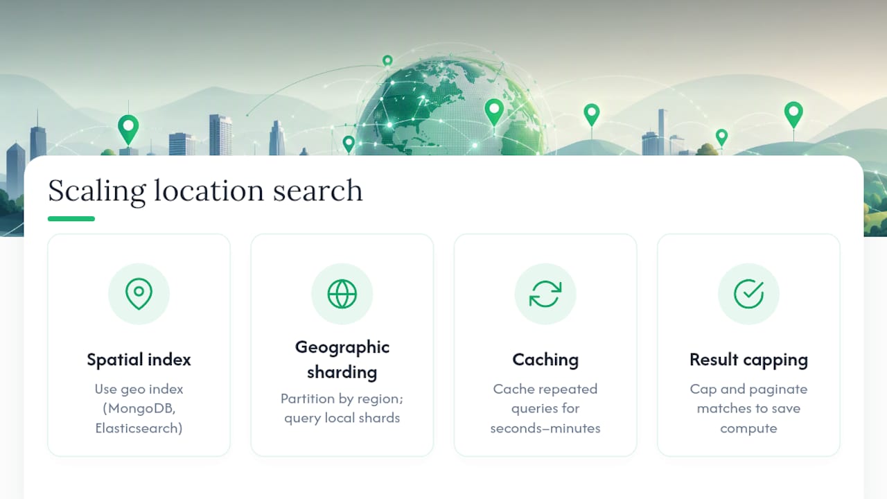
The first lever is making sure every geo query hits an index built for spatial data specifically, 2dsphere in MongoDB, geo_point mappings in Elasticsearch, rather than a generic numeric index pressed into service for coordinates. A generic index can technically hold lat/lng values, but it won't understand spatial relationships, so the engine ends up filtering results after the fact instead of during the index lookup, which is dramatically slower at scale.
The second lever is sharding or partitioning by geography when a single index grows too large for one node to serve efficiently. Splitting data by region, so a search for listings in Chicago never has to touch an index shard holding records from Lisbon, keeps individual queries fast even as the total dataset grows into the tens of millions.
The third lever is caching aggressively for popular or repeated queries. A search for "electronics near downtown Seattle" gets asked thousands of times a day in a busy market; caching that result set for a short window (seconds to a few minutes, depending on how often listings change) takes real load off the geo index without meaningfully hurting freshness.
Finally, result caps aren't just a UX choice at scale, they're a performance necessity. Returning every one of 40,000 matches within a wide radius is both useless to the user and expensive to compute; capping and paginating keeps both the database and the user's patience intact.
How Should Language and Culture Shape Location Search?
Address formats aren't universal, and a location search built around one country's conventions breaks quietly in another. A U.S. address expects house number, street, city, state, ZIP. Japanese addresses often work from largest unit to smallest, ward and block before street-level detail. Building a single rigid address form and geocoding pipeline around one format guarantees failed geocodes the moment the platform expands beyond its first market.
Autocomplete providers generally handle multiple address formats better than a hand-built parser, since they're built against real postal data for each region rather than assumptions baked in by a single engineering team.
Naming conventions for places matter too. A neighborhood, district, or informal area name that locals use constantly might not exist in any official postal database, but users will type it anyway. Search that only understands formal geocoded addresses will miss those queries; search that also indexes common local place names catches them.
Distance presets carry cultural assumptions as well. "Walking distance" means something different in a car-dependent suburban market than it does in a dense city built around foot traffic and transit. A 1 km preset labeled "walking distance" makes sense in central Tokyo; it might feel oddly small in a spread-out American suburb where a 5 km radius is closer to normal daily range. Presets that adapt by region, rather than a single global default, serve users better.
How Do You Handle Borders, Time Zones, and Edge-Case Locations?
Locations near a border or a time zone line create small but real problems that a straightforward radius query doesn't anticipate on its own.
A search centered a few kilometers from an international border will legitimately return results just across that line, and whether that's desirable depends entirely on context. A buyer searching for a nearby item generally doesn't care which side of a border a seller sits on, but currency, shipping regulations, or local pickup logistics might make a cross-border match impractical even though it's geographically the closest one. Flagging cross-border results distinctly, rather than silently including or excluding them, gives users the information to decide for themselves.
Time zones create a subtler issue: "open now" or "available today" logic needs to use the location's local time, not the searching user's device time zone. A search for businesses open right now, run near a time zone boundary, will show wrong results if the backend compares against the wrong clock. This is easy to overlook because it only breaks visibly near a boundary, and most testing happens comfortably inside one time zone.
Islands, exclaves, and locations with unusual or contested postal boundaries are rarer but still worth planning for. A bounding box or polygon drawn without accounting for these irregular shapes can silently exclude a legitimate location or, worse, include one that shouldn't match. Testing your spatial queries against a handful of known edge-case coordinates, a border town, an island, a location right at the international date line, catches problems long before a real user does.
How Do You Prevent Location Spoofing and Abuse?
Location data can be faked, and a search feature that trusts device-reported coordinates without question opens the door to abuse: sellers claiming a location closer to high-demand buyers than they actually are, or bad actors spoofing GPS to manipulate proximity rankings in their favor.
A few practical checks catch most of this without adding much friction for legitimate users:
- Cross-check device-reported coordinates against IP-based geolocation; a large, repeated mismatch is worth flagging for review rather than blocking outright, since VPNs and legitimate travel both cause harmless mismatches.
- Rate-limit how often a single account's stored location can change. A seller's listing address shifting several times a day has no ordinary explanation.
- Watch for coordinates that land exactly on suspicious patterns, a location precisely at 0,0 (the ocean point often returned by a broken or spoofed GPS reading) or a suspiciously round number that real-world GPS rarely produces.
- Treat server-verified addresses (entered and geocoded manually, then confirmed) as higher trust than raw device GPS for anything tied to a transaction, like a listing's pickup point.
None of these measures need to be visible to honest users. They run quietly in the background and only surface friction for the small share of behavior that looks like manipulation.
An Editorial Take on Building Location Search Right
Most teams treat location search as a solved problem because the APIs make it look easy: pass in a center and a radius, get results back. The part that actually determines whether the feature works is unglamorous, and it's the part most articles skip. It's the geocoding pipeline, the refresh cadence on stale addresses, and the decision about how much popularity should offset distance in your ranking formula.
The conventional advice leans hard on picking the "right" API or database, as though Elasticsearch versus MongoDB versus Algolia is the decision that matters most. It rarely is. A mediocre engine with clean, current geocoded data and a sensible radius default will outperform a best-in-class engine fed stale or ambiguous addresses every time.
If you're prioritizing, start with data quality: autocomplete on every input, a re-geocoding cadence tied to how often a business's location actually changes, and a policy for handling low-confidence points before they reach a user. Get that right first. Ranking weights and spatial query types are worth tuning, but they're optimizations layered on top of a foundation that either holds or doesn't.
— Marketplace
Sources
- Elasticsearch — geo_distance query
- Algolia — Geo location guide
- Meilisearch — Filter by geo radius
- MongoDB — $nearSphere